
Water risk · Spain
Which of your properties are at water risk?
Flood, drought and water stress for every address you manage, in one 0–100 Water Score. Official sources cited. Alerts when something changes.
Check an address for free
| Address | Water Score | Level |
|---|---|---|
| Carrer del Port 412, Badalona | 72 | High |
| Avinguda de la Pau 1180, Barcelona | 31 | Low |
| Carrer Nou 905, Girona | 58 | Medium |
| Passeig del Riu 2200, Tortosa | 88 | Very high |
Based on SNCZI, AEMET and ACA · Data as of 14 Oct 2026
Ter-Llobregat moves to alert phase
ACA · today · 09:30
The problem
Today, water risk is discovered when it is already too late
- SNCZI
- AEMET
- ACA
- CH Ebro
- Town council
- Cadastre
6 sources · 6 websites · 0 link to your portfolio
Sample data
Address · Water Score · Level · Data
Carrer del Port 412, Badalona
72High14 Oct 2026
Scattered maps
Six official sources, none linked to your portfolio.
No warning of changes
A building changes zone or phase and nobody tells you.
Hard to justify
A PDF with source and date beats an opinion.
Regulation
Flood risk is heading for the Land Registry
JUL 2026
Public consultation
PENDING
Royal decree approved
PENDING
Comes into force
PENDING
Risk on deeds and Land Registry
- Sales: the seller discloses in writing.
- Existing buildings: not just new builds.
- Town councils: adaptation plans.
The draft royal decree (proyecto de real decreto) on flood risk management, under public consultation since July 2026, provides that deeds and the Land Registry (Registro de la Propiedad) state whether a property is in a flood zone, whether it is a new build or a resale. Aguaindex tells you today which properties in your portfolio would be affected, with source and date.
Status: draft pending approval · MITECO · July 2026
See which properties in your portfolio are in a flood zone →How it works
Three steps. Nothing to install
Sample data
- 01
portfolio.csv · 2 rows
address;cadastral_reference
Carrer del Port 412, Badalona;
Passeig del Riu 2200, Tortosa;1234567AB1234C0001XY
Upload your portfolio
A CSV with addresses or cadastral references.
- 72 · High02
- River
- 72
- Surface
- 46
- Drought
- 44
- Stress
- 52
Get the Water Score
0 to 100, broken down by risk, with source and date.
- Warning03
Ter-Llobregat moves to alert phase
ACA · today · 09:30 · 3 properties
We alert you when it changes
An email when the mapping or the phase changes.
What you get
One PDF per building. One email when it changes.

Water Score report · v0.1 · 14 Oct 2026
Passeig del Riu 2200, 43500 Tortosa
Cadastral ref.: 1234567AB1234C0001XY
Basin: Ebro · Municipality: Tortosa
88
| Component | Score | Source | Date |
|---|---|---|---|
| River flooding | 88 | SNCZI (MITECO), T10 | 03/2024 |
| Surface-water flooding | 46 | AEMET · Cartografía municipal | 14 Oct 2026 |
| Drought and restrictions | 35 | CH Ebro, fase normalidad | 09/2026 |
| Water stress | 52 | MITECO · INE | 2025 |
Methodology v0.1 · aguaindex.com/en/methodology · Official data, date shown for each component
Page 1 of 3
FromAguaindex <alertas@aguaindex.com>
SubjectTer-Llobregat moves to alert phase · 3 properties in your portfolio affectedSample datatoday · 09:30
The Agència Catalana de l'Aigua has declared the alert phase for the Ter-Llobregat system (14 Oct 2026). In your Finques Vallmar portfolio, these properties change level:
- Avinguda de la Pau 1180, Barcelona · Drought: 31 → 54
- Carrer Nou 905, Girona · Drought: 40 → 58
- Carrer del Port 412, Badalona · Drought: 44 → 61
Alert-phase restrictions apply from 15 Oct 2026.
Water Score
A number you can check
The Water Score sums up four risks on a scale from 0 to 100: the higher the score, the higher the risk. The methodology is public and every data point cites its official source and update date. No black boxes.
Read the full methodology →River floodingSNCZI · MITECO
Surface-water floodingAEMET · municipal maps
Drought and restrictionsACA · River Basin Authorities
Water stressMITECO · INE
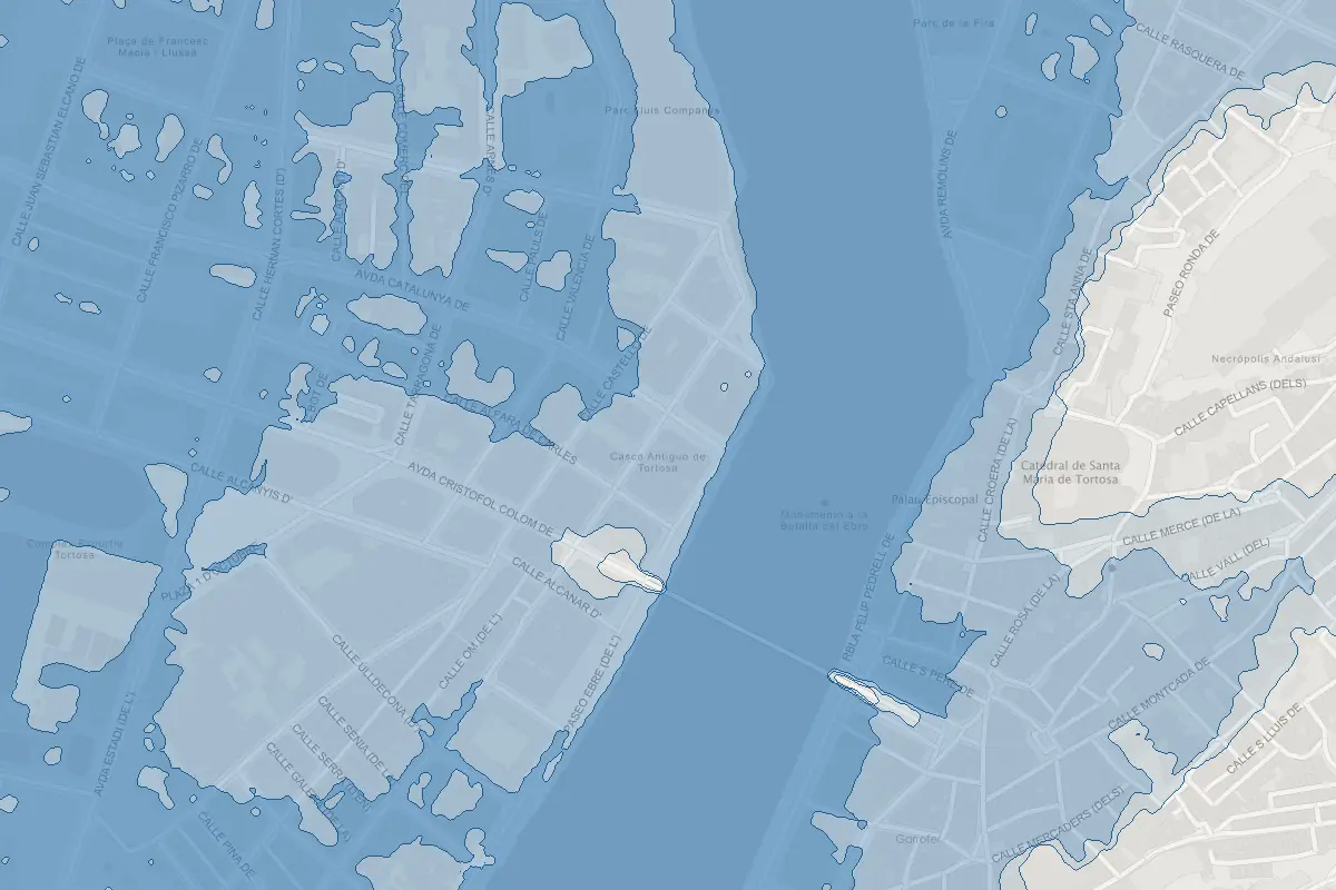 Sample data
- T10 · 10 years
- T100 · 100 years
- T500 · 500 years
Mapping: SNCZI · MITECO
Base: IGN (CC BY 4.0 scne.es)
Who it is for
Built for people who manage many properties
Property managers
Inform owners’ associations before the restriction or the warning arrives. One PDF per property, ready for the meeting.
Portfolio and fund managers
Physical risk for the whole portfolio in one exportable table. Useful for due diligence and reporting.
Agencies and integrators
If the royal decree comes into force, every sale in a flood zone will have to disclose it. Show it in your listings now via the API.
Pricing
Launch pricing
Reserve now, pay nothing. The first 50 customers keep launch pricing for one year.
Just one address? Check it for free →
Report
€19
per property
Full Water Score as a PDF with sources and breakdown. For sales, owners' meetings and due diligence.
Reserve early accessPortfolio 25
€49
per month
Up to 25 monitored addresses. Alerts, CSV and 25 PDFs per month.
Reserve early access- Recommended
Portfolio 150
€149
per month
Up to 150 monitored addresses. Alerts, CSV and unlimited PDFs.
Reserve early access Portfolio 1000
€399
per month
Up to 1,000 monitored addresses. Alerts, CSV and unlimited PDFs. API included.
Reserve early access
More than 1,000 addresses or need an integration? Write to us: hola@aguaindex.com
Reservation
Reserve early access
No payment, no commitment. We will write to you when access opens, and you keep the launch price.
Where does the data come from?
From official public sources: SNCZI (MITECO), AEMET, Agència Catalana de l'Aigua, the River Basin Authorities and the Cadastre. Every data point shows its source and update date.
What changes with the new royal decree on flood zones?
It is a draft under public consultation since July 2026. It provides that flood risk be stated in the deed and in the Land Registry for every sale, including resales, and that town councils draw up adaptation plans. It has not been approved yet; we will update this page when it is. See the Regulation section →
Does the Aguaindex report replace the land registry extract (nota simple)?
No. The extract will show what the official maps say. Aguaindex adds what the extract does not: heavy rain in urban areas, drought and restrictions, water stress, and it alerts you when things change.
Is the Water Score a prediction?
No. It is an organised reading of the official maps and the drought phases currently in force. It does not predict events; it tells you what the authorities say today about that address, and alerts you when that changes.
How is it different from a one-off risk report?
A report is a snapshot. Aguaindex keeps watching: if the maps or the drought phase change, you know.
Do you cover all of Spain?
Yes, for river flooding. Drought and surface-water flooding depend on the basin and the municipality: coverage is currently complete for Catalonia's internal basins and is being extended progressively to the other river basin districts and to the Valencian Community. Each data point states its coverage.
When does access open?
First quarter of 2027. Reserving does not commit you to anything.
Can I use the PDF with third parties?
Yes. The report states sources, dates and methodology, and is designed for owners’ meetings, insurers and buyers.
How many of your properties are in a flood zone?
Find out before your insurer does, and before it is written in the Land Registry.
Reserve early access